
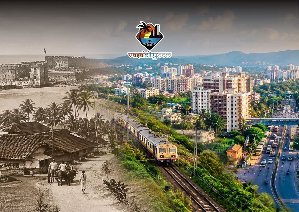
The Vasai-Virar evolution over the past several decades has transformed the region from a largely village-based landscape into one of the most recognisable urban areas in the Mumbai Metropolitan Region.
For older residents, the change is visible almost everywhere — in the skyline, roads, railway stations, shopping areas, traffic, housing societies and even in the way people spend their daily lives.
For newer residents, however, it can be difficult to imagine just how different Vasai-Virar once looked.
The region has a much older history than its recent residential boom. Vasai's coastal location, historic settlements and railway connectivity played important roles long before today's apartment towers appeared on the skyline. Western Railway records, for example, trace the first local train service between Virar and Backbay to 1867.
The modern Vasai-Virar evolution, therefore, is not the story of one sudden transformation. It is the result of decades of migration, transport expansion, urban planning, housing development and changing economic activity.
Here are seven major changes that help explain how Vasai-Virar became the city it is today.
Table of Contents
1. From Villages and Small Towns to a Large Urban Region
One of the biggest changes in the Vasai-Virar evolution has been the expansion of the urban footprint.
For generations, large parts of the region were characterised by villages, agricultural land, traditional homes, fishing communities, plantations and relatively low-density settlements.
The historic identity of Vasai was also closely linked to its coastal location and its Portuguese, Maratha and British-era legacy. The region's past remains visible through landmarks such as Vasai Fort, churches, old villages and traditional settlements. The Palghar district administration continues to identify Vasai as an important part of the area's historical heritage.
The arrival and expansion of railway connectivity gradually made the region more accessible to Mumbai.
Virar's railway history goes back to the 19th century, when local train services connected it with Bombay. Over time, the railway became one of the most important factors shaping residential growth along the corridor.
Today, the contrast is striking.
Traditional settlements continue to exist alongside apartment buildings, commercial complexes, industrial areas and rapidly developing neighbourhoods.
2. Affordable Housing Changed the Population
Housing affordability became another major driver of the Vasai-Virar evolution.
As property prices and housing pressures increased in Mumbai and its established suburbs, Vasai, Nalasopara and Virar became increasingly attractive to families looking for larger homes at comparatively accessible prices.
The result was a steady expansion of residential development.
Open plots and low-rise structures gradually gave way to housing societies, apartment complexes and larger residential projects.
This process also changed the social composition of the region.
People from different parts of Mumbai, neighbouring districts and other parts of Maharashtra and India began making Vasai-Virar their home.
That migration brought new languages, cultures, occupations, businesses and lifestyles into the region.
According to Vasai-Virar City Municipal Corporation, the area covered by the corporation is about 311 sq km and its population was around 12.22 lakh according to the 2011 Census.
The population story is important because it explains why the city's infrastructure requirements have grown so rapidly.
More residents mean greater demand for homes, schools, hospitals, transport, water, drainage, retail outlets, recreational facilities and public services.
3. The Railway Remained the Backbone of Growth
Even as roads and other transport options expanded, suburban rail remained central to the Vasai-Virar evolution.
For decades, thousands of residents have depended on railway stations such as Vasai Road, Nalasopara and Virar for daily travel towards Mumbai and other parts of the metropolitan region.
The railway corridor effectively helped turn what was once a distant residential option into a practical location for people working elsewhere in the Mumbai region.
Vasai Road also developed an important strategic role because the region connects not only towards Mumbai but also towards the northern parts of Maharashtra and other railway routes.
The city's official profile notes that Vasai-Virar is connected to Mumbai by rail and the Mumbai-Ahmedabad National Highway, while the Vasai-Diva railway route provides links towards Thane, Bhiwandi, Kalyan, Panvel and Navi Mumbai.
For residents, however, improved connectivity has also brought a familiar problem: congestion.
More homes have meant more commuters.
More commuters have meant greater pressure on railway services, roads, station areas and parking facilities.
So, the Vasai-Virar evolution has always had two sides — better access creating more growth, and more growth creating additional pressure on the transport system.
4. Planning Began to Shape the Region
Another important chapter in the Vasai-Virar evolution came with formal urban planning.
The Maharashtra government appointed CIDCO as the Special Planning Authority for the Vasai-Virar sub-region in 1990. CIDCO was responsible for surveys, development planning, regulation and coordination with local authorities. The region was subsequently handed over to Vasai-Virar City Municipal Corporation in July 2010.
This period was significant because Vasai-Virar was no longer being viewed simply as a collection of individual villages and municipalities.
The region increasingly had to be considered as a larger urban system.
Road networks, residential development, commercial zones, public amenities and future infrastructure needed to be considered together.
The challenge was that urbanisation was moving quickly.
In many locations, construction and population growth happened faster than the supporting infrastructure could develop.
That tension continues to influence conversations about roads, drainage, water supply, parking, public transport and open spaces.
5. The Creation of VVCMC Changed the Administrative Landscape
A major milestone in the Vasai-Virar evolution came on July 3, 2009, when the Vasai-Virar City Municipal Corporation was established.
The corporation brought together four municipal councils and 53 villages into a larger municipal framework.
This was more than an administrative change.
It reflected the fact that the region had grown beyond the scale of separate smaller urban settlements.
Vasai, Navghar-Manikpur, Nalasopara and Virar had increasingly become part of one interconnected urban economy.
The creation of a single municipal corporation also created a common framework for dealing with city-level issues such as town planning, roads, sanitation, water, public health and civic infrastructure.
The corporation currently describes Vasai-Virar as a rapidly growing city covering approximately 311 sq km.
The change can be seen on the ground.
Neighbourhoods that once felt separated by open land or village roads are increasingly connected through continuous residential and commercial development.
6. Local Businesses and Lifestyle Have Grown With the Population
Perhaps one of the most noticeable aspects of the Vasai-Virar evolution is the development of a local economy serving residents.
There was a time when many residents travelled towards Mumbai for major shopping, entertainment, specialised services and certain professional requirements.
That dependence has gradually reduced.
Today, residents can find a much wider range of businesses within the region — restaurants, cafés, supermarkets, gyms, coaching centres, salons, clinics, professional services, retail stores, entertainment venues and other businesses.
The growth of these businesses is closely connected to population growth.
A larger residential market creates demand.
Demand creates businesses.
Businesses create employment and local spending.
That, in turn, strengthens the city's own economic ecosystem.
The result is that Vasai-Virar is increasingly functioning not merely as a residential extension of Mumbai but as a sizeable urban market in its own right.
For local residents, this has changed everyday life.
A family can increasingly shop, eat, study, work, exercise and access services without travelling to Mumbai for every requirement.
7. Growth Has Created a New Set of Urban Challenges
The most complicated part of the Vasai-Virar evolution is that rapid growth has created problems alongside opportunities.
Traffic congestion is one of the most visible examples.
Roads that were originally designed for much smaller settlements now carry substantially more cars, two-wheelers, buses, goods vehicles and other traffic.
The same pressure can be seen around railway stations and major commercial areas.
Water is another major urban issue.
Large populations require dependable water infrastructure, and major regional projects have been developed to increase supply capacity. The Mumbai Metropolitan Region Development Authority's regional water supply project, for example, includes infrastructure intended to supply VVCMC and neighbouring areas.
Drainage and flooding remain equally important concerns during the monsoon.
As construction increases, protecting natural drainage channels, wetlands and open areas becomes increasingly important.
The question is no longer simply how quickly Vasai-Virar can grow.
It is also about how sustainably that growth can be managed.
The Old Vasai Still Exists Beneath the New City
Despite the dramatic Vasai-Virar evolution, the older identity of the region has not disappeared completely.
Traditional villages, old houses, churches, temples, farms, coconut trees, coastal landscapes and heritage structures continue to exist alongside modern construction.
Vasai Fort remains perhaps the most visible reminder of the region's long history.
The surrounding landscape also retains traces of an older way of life that existed before the large-scale residential expansion.
For residents who have lived here for decades, this contrast is particularly noticeable.
A road that once passed through fields may now be surrounded by buildings.
A quiet neighbourhood may have become a busy residential cluster.
A local market may have grown into a larger commercial centre.
The physical landscape has changed, but many elements of the area's cultural identity remain.
2014: Another Important Change
The Vasai-Virar evolution also needs to be viewed in the context of a larger administrative change.
On August 1, 2014, Palghar became Maharashtra's 36th district after being carved out of the former Thane district. Vasai taluka became part of the new Palghar district.
For the region, this added another layer to its administrative identity.
Vasai-Virar today is therefore simultaneously part of Palghar district and the wider Mumbai Metropolitan Region.
That dual identity helps explain its unique character.
It is close enough to Mumbai to be strongly influenced by the metropolis, yet large and distinct enough to have its own communities, businesses, heritage and local issues.
What the Next Decade Could Bring
The next stage of the Vasai-Virar evolution is likely to be defined less by simply adding more buildings and more by improving the systems that support them.
Transport connectivity, water supply, roads, drainage, public spaces, healthcare, education and environmental protection will become increasingly important as the population and built-up area continue to change.
The municipal corporation itself describes Vasai-Virar as a rapidly growing city and maintains dedicated town-planning resources for development plans, development rights and building regulations.
This makes planning particularly important.
The future Vasai-Virar will not be shaped only by developers or government agencies.
It will also be shaped by residents, local businesses, commuters, environmental groups, community organisations and the everyday choices made by people living here.
From Affordable Suburb to City With Its Own Identity
The story of Vasai-Virar evolution is ultimately a story of scale.
What was once largely a collection of villages and smaller urban settlements has developed into a major residential and commercial region.
Railways brought accessibility.
Housing development brought population.
Migration brought diversity.
Businesses created a stronger local economy.
Urban planning and municipal administration created larger systems to manage the growing city.
And rapid development created new questions about infrastructure, environment and quality of life.
The transformation is far from complete.
Vasai-Virar continues to change every year, with new buildings, businesses, roads and infrastructure projects altering the landscape.
Yet the region's older identity remains visible beneath the modern city.
That combination — heritage and high-rise development, village life and urban expansion, local culture and metropolitan influence — is what makes Vasai-Virar different from many other parts of the Mumbai region.
The Vasai-Virar evolution is therefore not simply about how the city has changed.
It is about how a once relatively quiet part of the region has developed its own identity while remaining closely connected to Mumbai.
And the next chapter of that transformation will depend on how successfully growth, infrastructure, environment and the city's historic character can exist together.